Unit key
Periglacial coombe / head — solifluction and gelifluction of frost-shattered chalk and flint under cold-stage climates (BGS Coombe deposits / Head). Colluvium — Holocene downslope wash over coombe or chalk. Solution — dissolution pipes / hollows, sometimes with thickened colluvium. Chalk — thin ploughsoil over chalk-dominated logs. Made ground — anthropogenic fill (often eastern portal / Countess). Ambiguous — reserved where the printed sheet still does not pin a clear stack.
Glacial ≠ ice on this corridor
Across Reports 4, 5 and 7 the dominant scientific language is periglacial / solifluction / cryoturbation / coombe / colluvium. True ice-contact till wording is rare, informal, and usually contradicted by the next sentence. BGS Salisbury Sheet 298 maps Head / Coombe on the Plain — not till. Clarke & Kirkland (2026) conclude Salisbury Plain remained unglaciated in the Pleistocene. BuyStonehenge’s desk search is how this public NSIP corpus was noticed; this gazetteer is not a rebuttal essay, only a geolocated reading of the printed elevations and deposit labels.
Field “glacial” wording: why it does not mean ice
Five evaluation trenches in this gazetteer carry a glacial_wording=y flag. Four of them sit together on the western approach interfluve in Report 4 (TR010025-000582); one is a separate eastern-portal phrase in Report 5 (TR010025-000584). Reading the printed sheets against the same reports’ geoarchaeology shows cold-climate Head / coombe, not ice-sheet till.
What was written
- R4-T241 (NGR 410399 141396, 99.48 m OD) — natural 24102 PDF p.81: “Compact, saluted chalk, glacial coombe deposit.” Neighbouring solution hollow 24105 is described in the interpretive text as a doline in soliflucted chalk. “Saluted” recurs elsewhere in Report 4 (“saluted chalk silt”) and is the sheet’s spelling of soliflucted.
- R4-T247 (410451 141409, 98.99 m OD) — natural 24703 PDF p.85: “Glacially affected coombe chalk. Very rare, subangular flint nodules, poorly sorted.” Overlain by possible colluvial subsoil 24702.
- R4-T248 (410488 141433, 98.72 m OD) — natural 24803 PDF p.86: “Glacially affected coombe chalk. Rare subangular flint nodules, poorly sorted.” Same stack pattern as T247.
- R4-T263 (410694 141501, 96.82 m OD) — geological features 26307–26308 PDF p.91: “Probably derived from a combination of glacial scouring and solution hollows”; “Probable scarring from glaciation.” The same trench also logs chalk-gravel striations (26303) and colluvium — a solution / peri-glacial hollow reading.
- R5-T511 (414910 142118, 73.2 m OD) — natural 51132 PDF p.75: deposit “laid down by fluvial action on glacial till within scraped out limestone, possibly by glacial activity or water movement.” Immediately above, 51131 is “Soliflucted chalk. Same as (51103)”; 51132–51136 are all equated to that same natural.
Deep-links use PDF viewer page numbers (#page=N). Printed footers can differ by 1 (e.g. Report 5 till sheet PDF p.75 / footer 74).
Spatial and authorship pattern
Report 4 is titled Archaeological Evaluation Report: Western Portal and Approach — Part 1: Text (April 2019; HE551506-AMW-HER-Z2_ML_M00_Z-RP-LH-0001). Corporate authorship is Wessex Archaeology Ltd for AECOM–Mace–WSP (AmW) on behalf of Highways England. Reports 4 and 5 share the same document author in the PDF metadata; no individual trench-sheet logger initials are printed in the Part 1 context tables. Report 4 §5.2 explicitly groups Trenches 241, 247, 248 and 263 (with others) as the central dry-valley / coombe crossing where “the natural geology comprised soliflucted or heavily cryoturbated Chalk” with “frequent periglacial stripes.” Those four flagged trenches span only ~300 m east–west at ~97–99.5 m OD on Normanton Down high ground near the proposed western portal (~100 m aOD) — one evaluation area, one report, one coombe-crossing cluster (glacial_wording_cluster=western_r4), not four independent ice claims. Winterbourne Stoke Crossroads barrow cemetery lies to the north-west at Longbarrow; the Report 7 Winterbourne Stoke coombe floor is a different, lower landform.
Report 5 is the matching Eastern Portal evaluation (Countess West; HE551506-AMW-HER-Z4-GN_000_Z-RP-LH-0001; same corporate line and PDF author). T511 sits alone in that eastern package, ~4.4 km east of the western cluster, on the lower approach falling toward the Avon (~70 m aOD at the far east of that site).
What the same documents mean by coombe / solifluction
Report 5’s geoarchaeology chapter defines coombe deposits as “material soliflucted downslope under periglacial conditions (alternate freeze-thawing), likely during the last glacial period.” Report 4’s results section uses the same process language: soliflucted / cryoturbated chalk, periglacial stripes and striations (e.g. T214 / T215 PDF p.71, T246). Report 7 likewise places Pleistocene periglacial coombe over chalk rockhead. BGS Coombe deposits (COD) are solifluction/gelifluction Head in chalk valleys — parent unit Head, not till. On Sheet 298 the Quaternary inventory is clay-with-flints, head variants, terrace deposits and alluvium; no ice-sheet till is mapped on the chalk plain around Stonehenge.
Sedimentological tests a true till would need
Ice-contact till (lodgement or melt-out diamicton) is normally argued from a combination of: a poorly sorted diamict fabric with a measurable clast orientation (fabric analysis); a significant exotic far-travelled clast assemblage; glacitectonic structures or bullet-shaped / striated clasts with consistent orientations; and a stratigraphic context compatible with ice-marginal deposition. None of these five trench sheets supplies that package. They record chalky coombe / soliflucted chalk, local flint, solution hollows, or — in T511 — an informal “till” sentence at 51132 PDF p.75 that the same register immediately equates to soliflucted chalk natural. Sample 51138 is a 40 L bulk of context 51135 (light green sand and degraded chalk), later assessed for charred plant remains (Appendix C flot table PDF p.86) — it is not a till micromorphology or clast-provenance assay.
Chalk control landscape
Where Anglian ice overrode chalk and left a preserved record — for example Royston to Saffron Walden — maps and boreholes show chalky till / Drift on chalk. This corridor does not: Sheet 298 is Head / coombe, and the flagged “glacial” trenches read as peri-glacial Head, not till-on-chalk. That is a like-for-like chalk comparison, not a claim that ice can never exist without till everywhere (Lee & Roberson 2025).
Why high-ground “glacial coombe chalk” is still Head
Ground levels at T241–T263 (~96.8–99.5 m OD) sit on the western approach interfluve / shallow coombe head near the western portal, tens of metres above Report 7’s Winterbourne Stoke coombe-floor rockhead (~71–76 m OD) and far above Holocene sea level (~0 m OD). Coombe and Head routinely mantle chalk slopes and interfluves under periglacial freeze–thaw; the adjective “glacial” on a coombe-chalk sheet is cold-stage climate shorthand, not evidence that an ice sheet overrode Normanton Down. Neighbouring blanks and naturals in the same appendix use the explicit labels “Soliflucted chalk”, “periglacial stripes”, and “Cryoturbated chalk.”
R5-T511 special case
The eastern “glacial till… glacial activity” phrase is the only till wording among the five, but it is field slang inside a machine-trench natural that the register itself identifies as soliflucted chalk (51131 = 51103). Report 5’s interpretive geoarchaeology never elevates T511 to ice-laid diamicton; coombe remains peri-glacial solifluction. Treat 51132 as a flagged wording outlier on the lower eastern portal (~73 m OD), not as a mapped till sheet.
OSL dating on this corridor
Published. Report 5 Eastern Portal (TR010025-000584) ran OSL on Trench 504 upper/lower colluvium and buried soil (50402 / 50403 / 50405); specialist report in Appendix D. Tentative ages in stratigraphic order: buried soil ~2.08±0.19 ka (LIA–RB), lower colluvium ~1.07±0.11 ka (late Saxon), upper colluvium ~0.47±0.05 ka — Holocene slopewash, not Middle Pleistocene till. Not published in the public pack. Phase 7B factual (TR010025-002259) scheduled four black-liner OSL rotary cores — STP70501, STP70503, STP70404, DTP70704 (coords on PDF pp.12/14; methods p.9) — sent to a specialist lab. No ages, no OSL appendix in that factual report. After cancellation of the A303 tunnel scheme, those results (if completed) have not appeared in the NSIP corpus; desk work cannot close that.
Elevations versus sea level
Cross-sections (m OD)
Elevation sections modelled on Mortimore et al. (2017) Fig. 16 (Proc. Geol. Assoc. 128) — the chalk corridor plotted in metres OD, the same visual language as the January 2026 Stonehenge Bottom flooding audit. Stacks are from printed Report 7 sheets; corridor points are this gazetteer.
Click a figure to enlarge · Esc or click outside to close
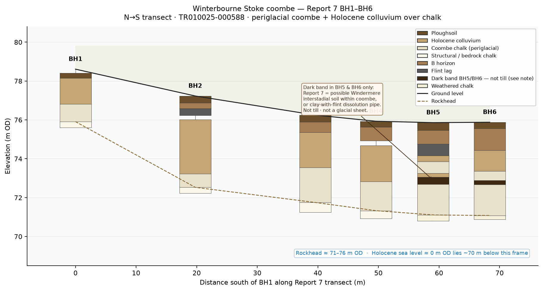
That dark band in BH5 and BH6 is not glacial till. Report 7 (TR010025-000588) logs a thin dark brown flinty silty clay within the periglacial coombe chalk in those two holes only. The report’s own alternatives are (1) a possible Windermere Interstadial buried soil, later overridden by renewed solifluction, or (2) a clay-with-flint lined dissolution pipe — the lower contacts are sharp, which is a poor fit for a normal in-situ soil profile. Either way it is a local coombe-hosted feature a few tens of centimetres thick, sandwiched in structureless chalk Head, not an ice-laid diamicton and not a sheet across the Plain. The corridor long-section’s brown veneer is the same family of deposits (ploughsoil, colluvium, coombe/head), drawn schematically between ground level and rockhead — again Head/coombe, not till.
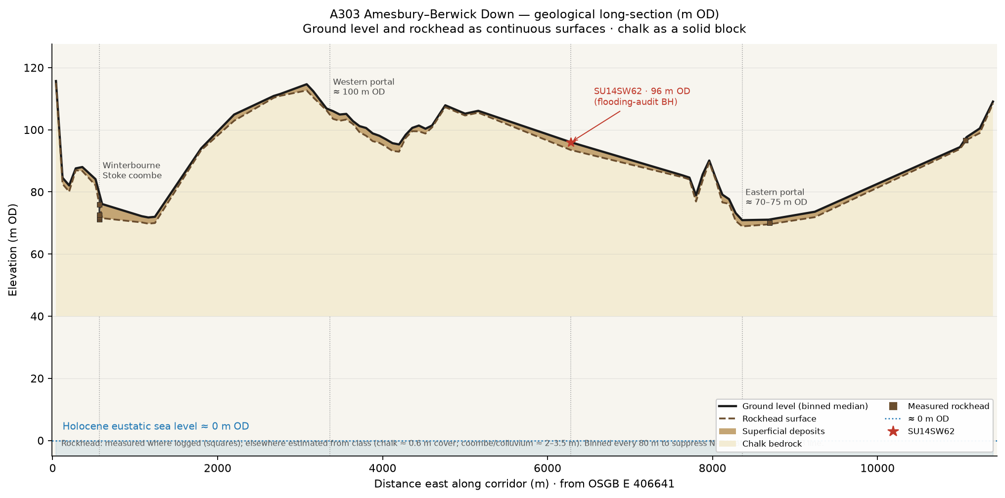
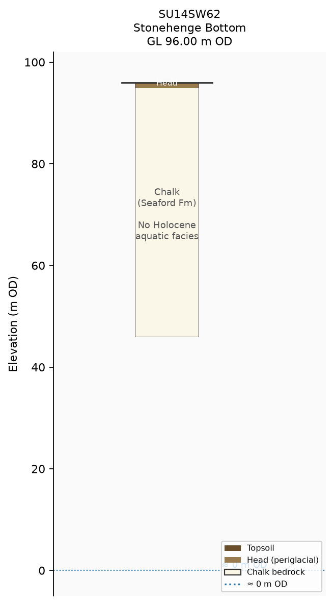
Holocene eustatic sea level sits near ~0 m OD. Ground levels in this gazetteer sit from 70.90 to 117.50 m OD. Winterbourne Stoke coombe rockhead (Report 7 BH1–BH6) is about 71–76 m OD. BGS SU14SW62 at Stonehenge Bottom is 96.00 m OD with no Holocene marine/aquatic facies. High Holocene water covering Stonehenge Bottom / the Plain is incompatible with these elevations — same argument as the January 2026 flooding audit.
Mortimore, R.N., Gelder, A., Moore, J., Brooks, S., Gallagher, L. & Farrant, A.R. (2017). Stonehenge — a unique Late Cretaceous phosphatic Chalk geology. Proceedings of the Geologists’ Association 128, 564–598. Fig. 16 is the style model for the elevation sections above.
Schematic sticks for every hole
Every gazetteer pin has a schematic OD stick in the separate sticks/ directory (also linked from the detail panel). Most are proportional stacks from the unit-label string between ground level and rockhead (measured where logged; otherwise a class-based cover estimate). Report 7 BH1–BH6 use the printed OD intervals; SU14SW62 is the flooding-audit stick. These are reading aids, not substitutes for the NSIP sheets.
How to read a pin
Each record carries OSGB36 easting/northing as printed, ground level (m OD) where printed, rockhead (m OD) only where the log states it (never invented), a short unit stack, and a glacial_wording flag independent of classification. Source document IDs link to the Planning Inspectorate published PDF where known.
Terrain & cover thickness
Ground-surface base is the Environment Agency LiDAR Composite DTM 2022 1 m hillshade (downsampled for the web map; not rockhead). Cover-thickness circles use the small bottom-left key (metres; bold ring = measured rockhead). Rockhead OD contours are a light RBF surface over measured rockhead where logged and class-estimated rockhead elsewhere — schematic, not a surveyed isopach. Toggle layers top-right. Optional BGS GeoIndex overlay (grey pins, default off) links to public scans; rockhead is not yet transcribed from AGS/scans.
Sources
- NSIP / National Highways factual reports (Planning Inspectorate): TR010025-000429 (PSSR); 000582 Report 4 Western Portal; 000584 Report 5 Eastern Portal; 000588 Report 7 ERT/boreholes; 002245 Phase 6 GI; 002259 Phase 7B factual; 002269 Phase 7a(i) factual.
- BGS GeoIndex boreholes (incl. SU14SW62) — map overlay “BGS GeoIndex” (grey pins → scan / AGS links where available; rockhead not yet transcribed from AGS/scans).
- BGS Coombe deposits lexicon (COD); Salisbury Sheet 298 memoir brief.
- Daw, T. 2026. Auditing the claim of Holocene flooding of Stonehenge Bottom.
- Lee, J.R. & Roberson, S. 2025. Proc. Geol. Assoc. 136, 101087 — limit of preserved glacial evidence; till vs head in boreholes.
- Clarke, A.P. & Kirkland, C.L. 2026. Commun. Earth Environ. s43247-025-03105-3.
- Corpus noticed via BuyStonehenge — The glacial A303 (desk search only; not a source of elevations).
- Environment Agency LiDAR Composite DTM 2022 1 m hillshade; Open Government Licence. (OS Terrain 50 was used briefly as an interim base before the EA 1 m tiles.)