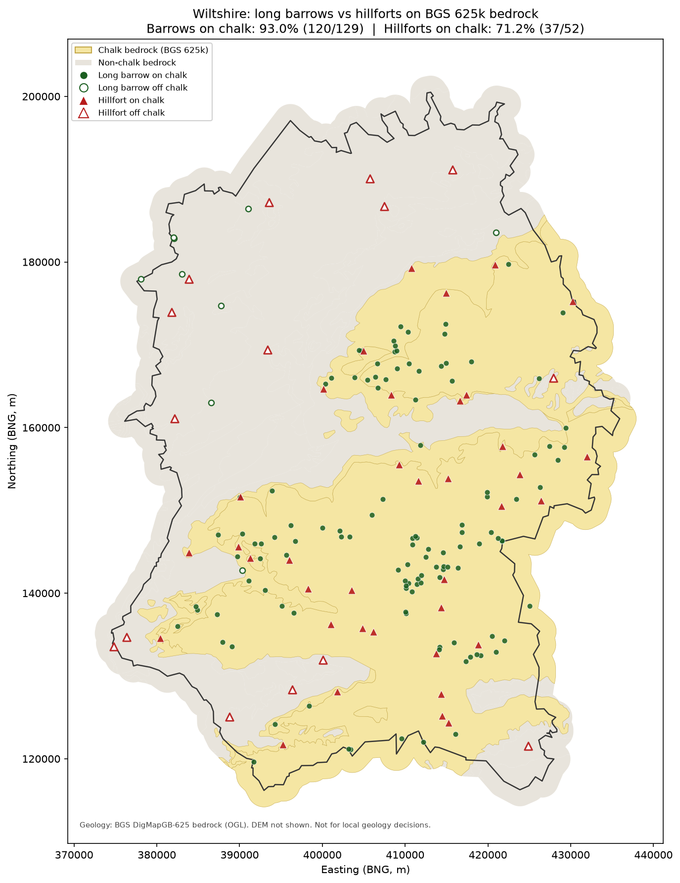
BGS DigMapGB-625 bedrock (OGL). DEM: AWS Terrarium z12. Internal analysis — not for publish.
| n | % chalk | elev median (m) | prominence median (m) | edge dist median (m) | NN median (m) | |
|---|---|---|---|---|---|---|
| Long barrows | 129 | 93.0 | 147.4 | 7.4 | 4557.0 | 1227.0 |
| Hillforts | 52 | 71.2 | 177.0 | 41.4 | 3134.0 | 4219.0 |
CHALK / GEOGRAPHY CHECK — Wiltshire long barrows vs 52 hillforts
Generated: 2026-09-09 (Europe/London)
Geology: BGS DigMapGB-625 bedrock (OGC API), Open Government Licence. Scale 1:625k — regional only.
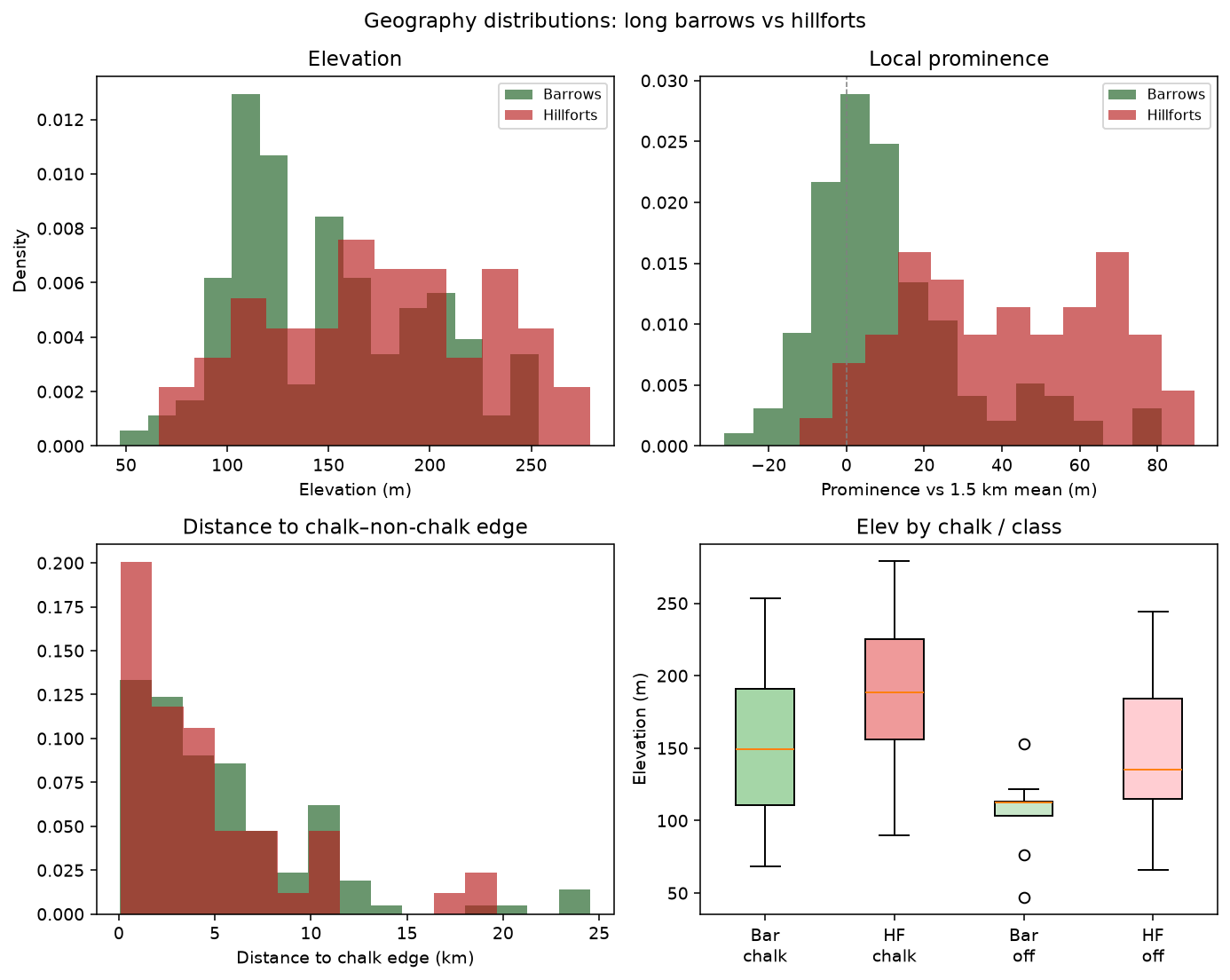
DEM: AWS Terrain Tiles / Mapzen Terrarium z12 (~30–40 m). Prominence = elev − mean in ~1.5 km ring.

═══════════════════════════════════════════════════════════════
ON CHALK
  Long barrows:  93.0%  (120/129)
  Hillforts:     71.2%  (37/52)

Both sets are overwhelmingly chalk-preferring. Shared chalk geology alone does NOT explain
the little spatial overlap — they sit on the same rock province.

═══════════════════════════════════════════════════════════════
SIMILARITIES
  • Both mostly on White/Grey Chalk Subgroup (BGS 625k).
  • Both occupy elevated chalk country (medians ~147.4 m barrows vs ~177.0 m hillforts).
  • Both have substantial easting/northing spread across Wiltshire chalklands
    (barrows E-spread 51323 m / N 66778 m;
     hillforts E 57170 / N 69601).
  • Median nearest barrow→hillfort ~3.5 km;
    hillfort→barrow ~3.1 km — cohabiting chalk, not co-sited.
  • Within 2 km of a hillfort: only 24.0% of barrows.

═══════════════════════════════════════════════════════════════
DIFFERENCES (niches on the same chalk)
  Elevation:     barrows median 147.4 m (IQR 110.6–186.8);
                 hillforts median 177.0 m (IQR 135.6–222.4).
  Prominence:    barrows median 7.4 m vs local 1.5 km mean
                 (mean 11.7 m);
                 hillforts median 41.4 m
                 (mean 40.4 m) — hillforts more locally proud.
  Chalk edge:    barrows median dist to chalk/non-chalk edge 4557 m
                 (IQR 1965–7462);
                 hillforts 3134 m
                 (IQR 1255–5587).
  Clustering:    barrows median NN 1227 m;
                 hillforts median NN 4219 m (hillforts more spaced).
  Off-chalk:     barrows non-chalk 7.0% — {'Great Oolite Group': 6, 'Mudstone, Sandstone And Limestone': 2, 'Mudstone, Siltstone And Sandstone': 1};
                 hillforts non-chalk 28.8% — {'Mudstone, Sandstone And Limestone': 5, 'Great Oolite Group': 4, 'Corallian Group': 3, 'Mudstone, Siltstone And Sandstone': 1, 'Lambeth Group': 1, 'Thames Group': 1}.

═══════════════════════════════════════════════════════════════
VERDICT (plain)
  They SHARE chalk (and high ground). They still occupy DIFFERENT niches: hillforts favour more
  locally prominent / scarped positions and are more widely spaced; long barrows spread across
  chalk plateaux and fringes with tighter clustering and different elev/edge profiles.
  Geology explains co-occurrence on chalklands; it does not explain the small site-level overlap —
  topography/prominence (and period/function) better separate the two sets.

CAVEATS
  • 625k geology generalises 50k — edge distances and chalk/non-chalk at scarp toes are coarse.
  • Terrarium DEM is coarse; prominence is a cheap proxy, not OS Terrain 5 / EA LiDAR.
  • Superficial deposits ignored (bedrock only).
  • Hillfort sample is the curated 52; barrows are 129 Wiltshire long barrows.